Click on images below to enlarge:
|
 |
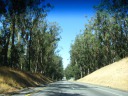
| Highway 156 on way to the coast
|
|
|
| The large eucalyptus grove that highway 156 passes through between
highways 101 and 1.
| Ditto.
|
|
| Highway 1 before Big Sur
|
|
|
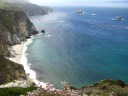
| The brushy and sandy beaches along highway 1 in Monterey. The Pacific
Ocean is hidden by the ridge.
| Ditto.
|
|
| Big Sur
|
|
|
|
|
| A panoramic looking down the coast taken from the first place we stopped
in Big Sur.
| A panoramic movie taken from the same place ("ibid").
| Ibid, a close-up of some coastal rocks.
| Big Sur's green hills, and perhaps a mountain hidden in the clouds.
Taken from a moving car.
|
|
|
|
|
|
| More Big Sur coast. The colors are almost unreal.
| Yet another stopping point, looking down along the coast. What a
stunning coastline.
| Ibid. "Great cheese comes from happy cows. Happy cows come from
California." I can see why--look at their view! :)
| Ibid, a close-up of the coast. Perhaps excellent? I took this picture
in high resolution. Look at the full-size image to enjoy the the rock
arch by the coast, among other things.
|
|
|
|
|
|
| Striated rock along the highway. The rocks are like this only at the
far north end of Big Sur.
| Close-up of the deep ridges and furrows within the rock.
| Another sample shot of striated rock. I took this picture in the
evening from a moving car in case my earlier samples didn't come out.
| A high-resolution shot of a cove near Rocky Creek Bridge. In addition
to the colors of the water, note the wildflowers in the foreground.
|
|
|
|
|
|
| Ditto, also high-resolution.
| From somewhere else in the same vicinity, a shot of the Pacific Ocean
that puts even more emphasis on the wildflowers.
| And another wildflowers-on-the-hillside shot. How'd you like to live in
this house with these views?
| A panoramic movie from the same location. Majestic.
|
|
|
|
|
|
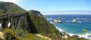
| Rocky Creek Bridge, at the other end of the pull-off. Excellent.
| A panorama encompassing both Rocky Creek Bridge and the coast.
| Di Yin spotted this creek beneath the bridge.
| A vertical panorama looking at the coast and down at the cove by Rocky
Creek Bridge. I took this standing at the edge of a cliff. I meant for
this picture to give a sense of vertigo. Did it work?
|
|
|
|
|
|
| A panorama of Bixby Bridge, like a grown-up Rocky Creek Bridge. It's
longer, needing more support outside the arch. It's about a mile south
of Rocky Creek Bridge. Excellent?
| An excellent, high-resolution shot looking south down the coast
from near Bixby Bridge.
| Ibid, just containing more of the coast. Also high resolution.
| Ibid, looking north up the coast. Also high-resolution. View the
full-sized image to see the house and terrace in the upper-right and
the rock formation in the lower-left.
|
|
|
|
|
|
Highway 1 south of Bixby Bridge winds up and into the mountains and
clouds. Also, Di Yin points out that the foreground part of the road
makes it obvious that it was blasted out of the mountain.
Again, this is a high-resolution shot; the view full-sized image to
truly enjoy it.
| A panoramic movie taken from Hurricane Point, a windy, foggy pull-off.
It's the top of the hill shown in the previous picture. I took this in
video form to show the fog/clouds blowing by.
| Ibid (another video from Hurricane Point).
| A photograph of the same scene (hence higher resolution than the
videos) in case you want more detail of the clouds and the coast.
|
|
|
|
|
|
| Looking south from a pull-off a mile farther on. Lacking fog, the area
was palpably warmer. High-resolution. Keep an eye on how the road
hugs the coast. Also, these were the first large, sandy beaches we
spotted in Big Sur.
| A multi-hued tide pool, as seen from yet another pull-out. This one had
crazily strong wind.
| We stopped again to photograph Point Sur. It's quite a mound rising
above the beachy, grassy coast. Also, don't miss the cows in the
foreground.
| A panorama of Point Sur. The lighthouse and other buildings are easy to
spot.
|